The Rocks Don't Lie:
A Geologist Investigates Noah's Floodby David R. Montgomery
Creationist book Grand Canyon A Different View claims that Noah's Flood deposited all the Grand Canyon rocks and then cut the Colorado River through it in a single year. No explanation for the multiple different layers of rock types or of the order of fossils preserved in those rocks. (Detailed refutation of the book here).
Bottom layer GC is Vishnu Schist, which started out as alternating layers of light colored quartz sand and dark mud, but now a hard crystalline rock. To form this particular rock, and then deform it like icecream, needs temperatures of at least 900 degrees C and 3000 times normal atmospheric pressure. That means it had to have been about ten miles below the surface, the roots of a mountain range which as long eroded away. Radiocarbon dating of the zircons in the rock give it an age of about 1.7 billion years. (Since zircons exclude lead when they form, all the lead in a sample must have come from the radioactive decay of uranium, and the ratio of the two gives a fraction of the4.5 billion year half-life.)
Running through the schist are granite dykes, which we know are younger because they have cooled in cracks in the schist.
On top of the are tilted layers made up of first deep-water limestone, then shale made from offshore mud, and then sandstone from a shoreline. These rocks show differing depths of an ancient sea.
Just these two sets of bottom rocks show that rocks once buried deep underground were brought to the surface, exposed to the elements to completely erode all the top rocks, and then buried again deep below an ancient sea. After that, it got tilted up and planed off by erosion a second time.
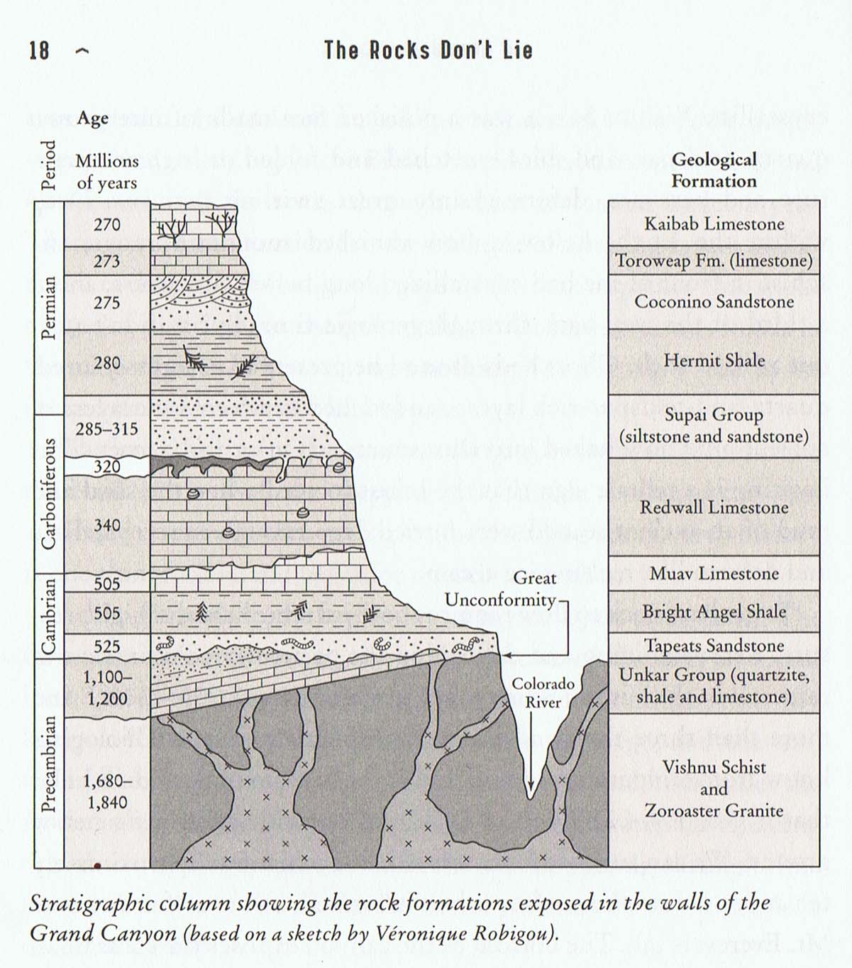
The next set of rocks are only 525 million years old. Over a thousand million years of rock has been eroded from the record. The Tapeas Sandstone has fossils of simple worms and because its very hard, forms steep walls.
On top of it are laid the softer Bright Angel Shale, which has trilobite fossils, and then Muav Limestone and then there is another discontinuity of 100 million years. Then the Redwall Limestone, laid down in iron rich sea water, with clam fossils.
The Supai Group is alternating layers of (harder) sandstone, which forms little cliffs, and (softer) shale, which forms little ledges, so that whole thing is a series of steps. This one formation is a telling rebuttal of idea that all sediments laid down at once in NF. The individual layers of sand, clay and silt would take weeks to settle out even when water is calm. Each episode needs a separate time frame, and there are hundreds of thousands of different layers, coarse to fine, coarse to fine, all laid down in another ancient ocean.
Above this is the Hermit Shale, soft and easily eroded so forms ledges. It is full of fossil ferns and amphibians, telling us that this is the remains of a temperate coastal jungle.
Above this is the Cocomino Sandstone, a massive layer of pure white quartz sand - former dunes on land, not under the sea, because delicate reptile tracks would have been washed away by waves under water.
Above that is the limestone of the Torowep Formation, evidence that a sea submerged the desert sand dunes. Finally, at the top is the Kaibab Limestone, with fossil coral reefs.
Problems for the creationist idea that NF responsible for all the sediment
- complete lack of modern animals among the fossils - all just (long) extinct species
- all the different rocks require different formation conditions - under sea, under pressure, on land, under rivers
- the species that form limestone - millions of tiny calcium shelled organisms, require time to grow and only do so in clear conditions - if water swirling around could not have formed limestone
- the alternating layers require a very long series of events and environments
History of the debate.
Long before science and modern geology, religious scholars debated whether NF was a local or a global event. St Augustine (4th C) certain that both Scripture and the natural world shared a common author, advocated flexible biblical interpretation that cd be adjusted in light of what you learned about natural world. If what you cd see contradicted biblical interpretation, then modify yr thinking.
Leonardo da Vinci one of first to question NF as a way of getting fossil sea shells up to mountains. Watching how currents move sediment, he realized that heavier than water objects quickly sank to the bottom. And he cd not see how flood waters cd have formed the geography. f the water covered all the world, it wd have formed a perfect sphere, so where did it get the slope to propel it. How cd it erode valleys without moving? And where did all the water go afterward?
Even in 1600's recognized that probably a local flood because (a) simply not enough water on Earth to submerge highest mts (and foolish to invent new miracles to cope with that fact - God miraculously created extra water and then miraculously made it disappear) and (b) the few generations between Adam and the Flood cd hardly have populated the whole planet. Since there must have only been comparatively few people, all living around ME, would not have made sense for God to punish uninhabited areas.
Steno, the grandfather of geology, 1666 dissected a shark and realized that it's teeth identical to the fossilized things which were common in hills near Florence, and which had previously been written off as minerals growing spontaneously within rocks. Pointed out that if that were so, shd be surrounded by cracks as expanded. He was the first to explain that rocks were made of consolidated sediment washed off the land, and realized that this meant that the oldest layers were at the bottom and the youngest at the top. Fossils were the remains of creatures buried in the sediments, but only the hardest bits (like teeth) survived decomposition.
Creationists thought Siberian mammoth discoveries confirmed NF - flood washed elephants all way fro Africa, scouring the valleys of Himalayas on the way. But how cd wash 2000 miles intact? And why no lions or zebras or giraffes at all? Obvious that had to have died in situ. And if look at maps, can see that valleys all diverge from a central high point, so cd not have been cut by a single flood flowing over everything.
Wide range of theological interpretations of NF to explain where the water had come from and gone, and how various animals had survived and others gone extinct, where fossils came from etc etc. Most of these had to be wrong, which meant that many people were misinterpreting the Bible. Which, if any, of the Biblical explanations cd be true?
1790's James Hutton recognized that land continually being eroded into rivers and sea. But where was new land coming from? If it were just precipitating out and gradually filling the oceans, it would appear in layers. But the fact that it appeared heated and tilted or buckled, meant due to action of Earth's internal heat and volcanic action. The proof was the granite veins which intruded through sedimentary rock layers. Hutton's ideas of a continually regenerating geology directly contradicted the current view of a recently created, decaying world.
At Siccar Point he found geology which confirmed his ideas. Vertical layers of gray sandstone jutted upwards, overlaid by layers of tilted red sandstone, and in between lay gray rubble that looked just like a modern beach. The only way to account for these strata was if there had been several cycles of deposition, erosion, submerging and uplift.
If Roman ruins were still standing 2000 years later, how could you fit the geology of places like Siccar Point into a time frame of 4000 years?
1815 surveyor and canal builder William Smith published the first regional geological map. He carefully documented a consistent, well-ordered succession of rock types across England that could not be the result of a single chaotic flood. After this map, NF enthusiasts dropped idea that cd find evidence in rocks and fossils. All that now lay in pre-Genesis history.
Discovery of a library of clay tablets in ancient town of Ninevah showed that Genesis was based on earlier pagan stories about creation of the world, the tower of Babylon, and a great flood. The flood stories all seemed to be about a historical Mesopotamian flood rather than a global event.
Original Hebrew version of OT had no vowels or spaces. The marks to indicate vowels, punctuation and spaces were invented by rabbis long afterwards. Striking differences between Greek and Hebrew versions of Bible, and the later Latin translation. Martin Luther dismissed the Latin version as flawed, and went back to oldest sources. The Council of Trent bishops disagreed with Luther's claim that lay people should read the Bible and make their own decisions. The bishops wanted to maintain the authority of priests, so they came to the counter-intuitive conclusion that the translation was more authentic than the original.
How long did NF last? Genesis 7:24 and 8:3 say it lasted 150 days. Genesis 8:6-12 says it rained for 40 days and nights, then receded from Earth in just 2 weeks (ie a total of 54 days). Elsewhere it lasted ten and a half months from the 17th day of the second month of Noah's 600th year (Genesis 7:11) to the flood waters receding enough for Noah to open the Ark on the first day of his 601st year. How can all these things be true?
(Extract)
After teaching geology at the University of Washington for a decade, I had become embarrassed that I hadn't yet seen the deep canyons where tremendous Ice Age floods scoured down into solid rock to sculpt the scablands. So I decided to help lead a field trip for students to see the giant erosion scars on the local landforms.
We drove across the Columbia River and continued eastward, dropping into Moses Coulee, a canyon with vertical walls of layered basalt. We gathered the students on a small rise and asked them how the canyon had formed. They immediately ruled out wind and glaciers. The valley was not U-shaped like a typical glacial valley, and none of us could imagine how wind might gouge a canyon out of hard basalt. But neither were there rivers or streams. After a while I pointed out that we were standing on a pile of gravel. I asked how the rounded granite pebbles came to be there when the closest source of granite lay over the horizon. Silence.
Hiking through eastern Washington canyons littered with exotic boulders is a standard field trip for beginning geologists. It takes a while to register what you see. A dry waterfall hundreds of feet high in the middle of the desert. Giant potholes where no river flows today. Granite boulders parked in a basalt canyon. Gradually the contradictions fall into place and a story unfolds. Where did wayward boulders the size of a car or house come from? What was the source of the water that moved them around and carved the falls? Today, even novice geologists can conjure up eastern Washington's giant floods.
Long before the discovery of the scablands, geologists dismissed the role of catastrophic floods in interpreting European geology. By the end of the 19th century such ideas not only were out of fashion but were geological heresy. When J Harlen Bretz uncovered evidence of giant floods in eastern Washington in the 1920s, it took most of the 20th century for other geologists to believe him. Geologists had so thoroughly vilified the concept of great floods that they could not believe it when somebody actually found evidence of one.
Bretz was a classic field geologist and a controversial figure throughout his career. In 1925 he presented the story of the region's giant floods, seeing what others at first could not - and then would not - see. He spent his lifetime piecing together the story of how a raging wall of water hundreds of feet high roared across eastern Washington, carving deep channels before cascading down the Columbia River Gorge as a wall of water high enough to turn Oregon's Willamette Valley into a vast backwater lake.
Bretz found exotic granite boulders perched on basalt cliffs hundreds of feet above the highest recorded river level. In the scablands, a desolate region stripped of soil, he came across dry waterfalls and potholes hundreds of feet above the modern river. Gigantic gravel bars deposited within dry valleys implied deep, fast-flowing water. Streamlined hills rose like islands, extending more than 100 feet above the scoured-out channelways.
He realized the chaotic landscape had been carved by an enormous flood that chewed deep channels through hundreds of feet of solid basalt. The ancient flood deposited an enormous delta around Portland, Oregon, backing up flow into the Willamette Valley. The waters, he eventually realized, could have come from catastrophic drainage of Lake Missoula, an ancient, glacier-dammed lake in western Montana.
Bretz was ridiculed until 1940, when geologist Joe Pardee described giant ripple marks on the bed of Lake Missoula. The 50-foot-high ripples, he said, were formed by fast-flowing currents and not by the sluggish bottom water of a lake. Only sudden failure of the glacial dam could have released the 2,000-foot-deep lake. The catastrophic release of 600 cubic miles of water through a narrow gap would sweep away everything in its path. In 1979, when Bretz was 97 years old, the Geological Society of America awarded him its highest honor, the Penrose Medal.
Recognition of the Missoula flood helped other geologists identify similar landforms in Asia, Europe, Alaska, and the American Midwest, as well as on Mars. There is now compelling evidence for many gigantic ancient floods where glacial ice dams failed time and again: At the end of the last glaciation, some 10,000 years ago, giant ice-dammed lakes in Eurasia and North America repeatedly produced huge floods. In Siberia, rivers spilled over drainage divides and changed their courses. England's fate as an island was sealed by erosion from glacial floods that carved the English Channel. These were not global deluges as described in the Genesis story of Noah, but were more focused catastrophic floods taking place throughout the world. They likely inspired stories like Noah's in many cultures, passed down through generations.
Since devastating floods were a fact of life on the margins of the world's great ice sheets, people in those areas probably witnessed them. Early missionaries in eastern Washington reported stories of a great flood among Yakima and Spokane tribes, who could identify locations where survivors sought refuge. An Ojibwa Indian legend from around Lake Superior tells of a great snow that fell one September at the beginning of time: A bag contained the sun's heat until a mouse nibbled a hole in it. The warmth spilled over, melting the snow and producing a flood that rose above the tops of the highest pines. Everyone drowned except for an old man who drifted about in his canoe rescuing animals. The native inhabitants of the Willamette Valley told stories of a time the valley filled with water, forcing everyone to flee up a mountain before the waters receded.
Did survivors of such events pass their stories down through the ages? Could the biblical story of Noah, on some level, be real?
Tsangpo Gorge Flood, Tibet
The Legend: Local folklore describes a traditional Buddhist pilgrimage that circled a small peak ringed by lake terraces. The pilgrims commemorated how Guru Rimpoche brought Buddhism to Tibet by defeating a powerful lake demon, draining its home to reveal fertile farmland. A local temple, which sits on top of a stack of ancient lake sediments, has a striking mural of Guru Rimpoche above a lake at the gorge entrance. The Temple's head lama believes the ocean once covered all of Tibet.
The Evidence: During a 2002 expedition, geologist David Montgomery studied how the Tsangpo River once sawed through rock, carving the world's deepest gorge. His team discovered ancient shorelines and 1,200-year-old wood fragments in lake sediments dating to around the time Rimpoche arrived in Tibet. At the head of the gorge, glacial debris was plastered on both sides of the valley, confirming that a massive tongue of ice once plunged down a nearby 25,000-foot-high peak. Two levels of terraces extending upstream indicated a wall of ice and mud had dammed the river, backing up a lake that filled the valley. Once the lake filled enough to breach the dam, a rush of water roared down the gorge, scouring out everything in its path.
Grand Canyon Flood
The Legend: A local Native American tribe, the Havasupai, attributes the canyon's carving to a catastrophic flood down the Colorado River that occurred when the god Ho-ko-ma-ta unleashed a tremendous rainstorm. A more benevolent god, Pu-keh-eh, put his daughter in a hollowed-out log to save her from the monstrous current. After the flood receded, she crawled out and became mother of all humanity.
The Evidence: The rocks exposed in the canyon walls could not have settled during a single flood because they alternate many times in color, grain size, and composition. Although floods did not create the canyon, evidence suggests they helped shape it. Huge boulders are perched hundreds of feet above the river. Floods capable of stranding boulders so high would have been spectacular. The breaching of cooled lava dams that impounded the river may have launched these catastrophic floods. But these deluges occurred at least 400,000 years ago, long before people made it to the continent. The Native American tale of how the canyon formed is apparently an attempt to make sense of mysterious landforms.
Black Sea Flood
The Legend: In the story of Noah's Ark, the book of Genesis says Noah lived during a time when all other people on Earth were evil. God became angry and decided to create a giant flood to kill everyone except Noah and his family. God told Noah to build a boat called an ark, big enough for himself, his wife, his sons, their wives, and at least two of every animal. Once the ark was built, God sent a rainstorm that lasted 40 days. The deluge rose higher than the tallest mountain. When the waters receded, Noah's family and animals left the ark and repopulated the Earth.
The Evidence: After refuting the possibility of a global flood, geologists dismissed suggestions that the story of Noah's Flood might be rooted in some sort of fact. Then, in 1993, oceanographers Bill Ryan and Walter Pitman of Columbia University used sonar to survey the floor of the Black Sea - and found evidence supporting the story after all. Submerged beneath the surface were ancient streambeds, river-cut canyons, and shorelines. High-resolution seismic reflection profiles showed a former land surface buried in the seafloor sediments. Drill cores from the seafloor contained roots of shrubs covered by marine mud. Ryan and Pitman argued that over 7,000 years ago, the Mediterranean began to rise, breaching rocks along the Istanbul Strait, a waterway that helps form the boundary between Europe and Asia today. The event caused the Mediterranean to spill into the Black Sea, triggering a catastrophic flood.
Were early farmers in the area forced to flee as their world disappeared underwater? Archaeologists found the rising waters coincided with the onset of the initial migration of farming cultures into Europe and the floodplains of Mesopotamia. Wherever they came from, the first farmers arrived in southern Mesopotamia shortly after the filling of the Black Sea. Did they bring the story of a great flood that destroyed their world?
More books on Religion
More books on Legends
Books by Title
Books by Author
Books by Topic